

Socioeconomic Research
SES Team:
Walter Allen – Allan Murray Cartter Professor of Higher Education within the UCLA Department of Education, Graduate School of Education and Information Studies
Trevon Fuller – Assistant Researcher, Center for Tropical Research, UCLA Institute of the Environment and Sustainability
Paul Sesink Clee – Graduate Research Fellow, Drexel University - Biology Department
Anthony Trochez – Ph.D. candidate, Graduate School of Education and Information Studies
Overview of the Incorporation of Socio-economic Data into CAB Alliance Research
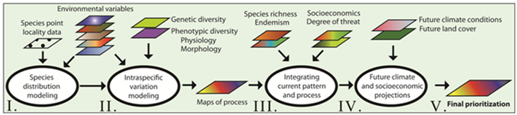
Fig. 1. Flowchart of species distribution and spatially explicit modeling approaches to map current and potential future biodiversity across a landscape. The results, when combined with degrees of threat and socioeconomic impacts, can be used to prioritize areas of importance for conserving biodiversity pattern and process under climate change.
Results of species distribution and intraspecific variation modeling will be used to map current and future reservoirs of adaptive evolutionary potential and determine how these relate to currently protected areas (Fig. 1). Using these criteria, we will propose new conservation areas that map to areas of high evolutionary potential and physiological/plastic buffering potential. Successful conservation action planning must consider the needs of people who live near protected areas. The socio-economic research will entail collecting detailed household-level data to inventory: 1) consumption patterns, 2) income sources, 3) the extent to which households depend upon extracting forest products, 4) economic practices, 5) social attitudes, 6) cultural beliefs (e.g. sacred forests), and 7) built infrastructure. These socio-economic aspects are also influenced by changes to the environment and lived context [1].
The research design for collection of primary data will conduct in depth interviews and oral histories with select community informants about the larger historical, cultural, economic, and social context of this project. These oral life histories will also guide the development of social survey instruments. Key informants will be identified among the traditional leadership in the area (e.g., tribal chiefs, and village elders). Informants will summarize group oral traditions and beliefs about how climate change might be related to generational changes in dress, diet, hunting, agriculture, economic practices and declines in plant or animal species.
Next social survey instruments guided by research questions and key informants data will be designed and evaluated for validity, reliability, and cultural integrity (using back translation procedures and local expert panels to insure the cultural relevance and conceptual accuracy of measures). A sample of household respondents will be selected from villages and towns in the targeted area using a multi-stage, cluster sampling design with probability proportional to size [2]. The final instrument will be used to survey a representative sample (based on a power analysis) of adult household informants.
Research Questions, Hypotheses, and Results
Research Question 1. Do the establishment of protected areas and transportation infrastructure in rural Cameroon lead to population growth?
Background: In a continent-wide study of Africa, Wittemeyer et al. [3] found that the rate of population growth near parks is higher than in other rural areas. This finding prompted us to confirm the parks-growth relationship using more recent population growth data from Cameroon. A related research question investigates the association between transportation infrastructure and rural population growth. Since the 1970s, roads and forest clearing have expanded significantly in Central Africa [4, 5]. In the US, the establishment of the interstate highway system in the 1950s led to increased population in suburbs and decreased population in urban areas [6]. This raises the question of whether road expansion in Cameroon explains patterns of population growth.
Hypotheses: We hypothesize that, historically, protected areas have been established in Cameroon in areas with low market potential. For example, since Cameroon’s southern and eastern regions have low population density and little trade with neighboring countries due to poor roads [7, 8], we expect that many protected areas would have been established in these two regions. Other variables that might explain forest clearing and the establishment of protected areas include soil attributes [5, 9]. For example, sites with soils suitable for agriculture may be more likely to be deforested.
Results to date: In Cameroon, at the department scale (n=58), road length explains the rate of population growth from 1976-2000 (=0.355, Fig. 2). Supporting Wittemeyer et al., we found that the rate of population growth near parks in Cameroon exceeds the average growth rate in rural areas (t = 10.322, df = 16.011, p = 1.75 × 10⁻⁸, Fig. 3).
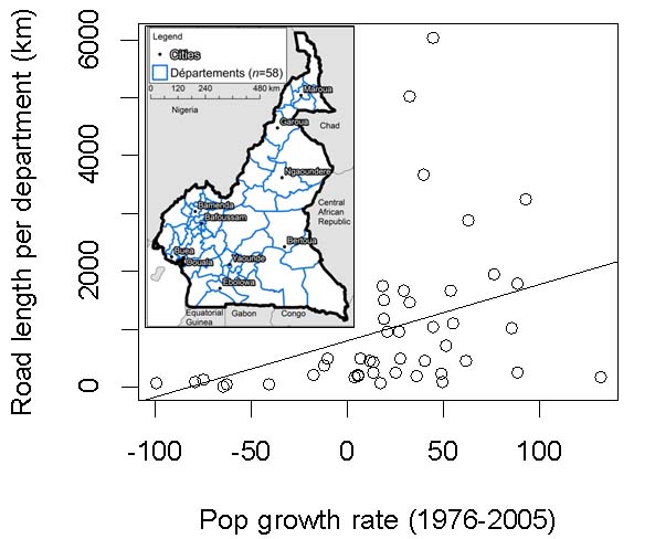
Figure 2. Effect of roads on population growth in rural Cameroon.
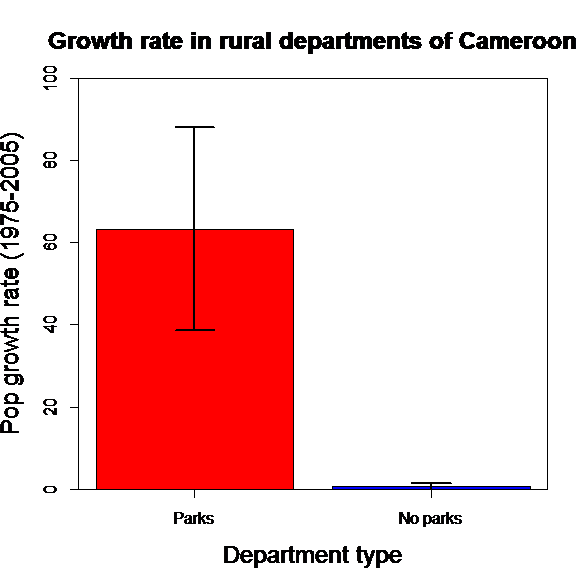
Figure 3. Impact of protected area establishment on population growth in rural Cameroon.
Research Question 2. How has the development of infrastructure associated with the new deep water port at Kribi, Cameroon affected trade and biodiversity? How will such development evolve in the future?
Background: Cameroon’s existing container port at Douala is operating at capacity [7]. This has prompted the development of a new deep water port 30 km south of Kribi in the southern region of Cameroon. The capacity of the new port, which was begun in 2011 and will be completed in 2014, will be 100 million tons per year [10]. Land surrounding the port is being converted into an Industrial Zone with a shoreline of 30 km, an area of 260 km2. The port will be used to export iron ore, aluminum ore, oil, and natural gas. The port cost 498 million USD, 15% of which was funded by the Cameroonian Ministry of Economy, Planning, and Regional Development and 85% by the Export Import Bank of China. New roads have already been constructed to provide access to the port. In addition, a rail line is under development that will traverse southern Cameroon and link Kribi to the Republic of Congo and the Democratic Republic of Congo (Fig. 3).
The Ministry of Economy, Planning, and Regional Development has streamlined customs to facilitate trade at the port, which is predicted to generate 12.85 billion USD in tax revenue beginning in 2014. The first phase of the port is being constructed by China Harbor Engineering Company Ltd [10]. The Dutch firm Royal Haskoning DHV was contracted by the Ministry to design a strategic plan, a spatial master plan, and a development plan for the new city that will surround the port, which is expected to have a population of 80,000 [11].
Hypothesis: Currently, overland transport in Cameroon and Central Africa in general is difficult and impedes trade [7, 8]. Since reductions in trade costs increase income levels [12], we expect the establishment of road and rail lines serving the port to decrease trade costs, increase income levels, and attract a substantial number of migrants to the new city. The development of roads, rail, and port infrastructure is likely to impact biodiversity by causing land clearing (Fig. 4).
Results to date: We have analyzed the effect of development and export policies on deforestation in the Congo Basin, to provide predictions about the pattern of development that is likely to result from the establishment of Kribi Port. Results indicate a significant relationship between forest loss since 2000 measured by remote sensing and Chinese timber imports (Fig. 5, R2=0.458). This is due to the fact that China is the most important buyer of timber harvested in Central Africa according to the World Trade Commission. Furthermore, in Cameroon, the rate of forest clearing since 2000 is also significantly associated with the number of middle class households in rural areas (Fig. 6, R2= 0.47). This may be due to increased consumption of timber with increasing household wealth.
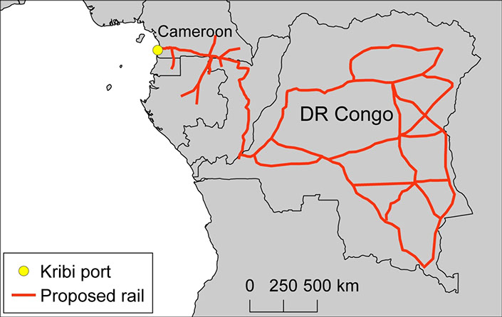
Figure 4. Expansion of road networks in the Congo Basin.
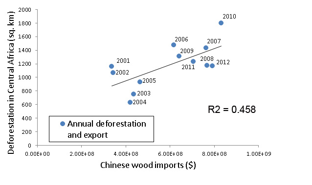
Figure 5. Deforestation rates in Central Africa increase with Chinese wood imports.
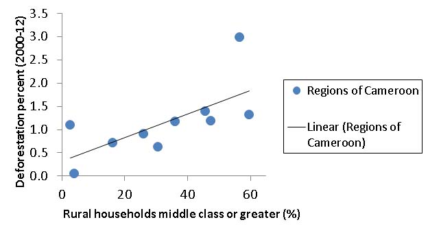
Figure 6. Deforestation increases with rural household wealth.
Introductory R texts
English
Emmanuel Paradis. R for Beginners.
French
Christophe Genolini. Lire; Compter; Tester…avec R.
Maxime Hervé. Aide-mémoire de statistique appliquée à la biologie.
Andrew Robinson. Brise Glace-R.
Mayeul Kauffmann. Aide Mémoire R.
Emmanuel Paradis. R pour les débutants.
References
1. Murphree MW. Congruent objectives, competing interests and strategic compromise: concept and process in the evolution of Zimbabwe's CAMPFIRE, 1984-1996. In: Brosius JP, Lowenhaupt Tsing A, Zerner C, eds. Communities and Conservation: Histories and Politics of Community-based Natural Resource Management. Walnut Creek, California: Altamira Press, 2005: 105-48.
2. Bennett S, et al. A simplified general method for cluster-sample surverys of health in developing countries. World Health Statistical Quarterly 1991; 44: 98-106.
3. Wittemyer G, et al. Accelerated human population growth at protected area edges. Science 2008; 321: 123-6.
4. Laporte NT, et al. Expansion of industrial logging in Central Africa. Science 2007; 316: 1451.
5. Mertens B, Lambin EF. Land-cover-change trajectories in southern Cameroon. Annals of the Association of American Geographers 2000; 90: 467-94.
6. Baum-Snow N. Did highways cause suburbanization? Q J Econ 2007; 122: 775-805.
7. Dominguez-Torres C, Foster V. Cameroon's Infrastructure: A Continental Perspective. Africa Infrastructure Country Diagnostic. Washington, DC: World Bank, 2011.
8. Buys P, et al. Road Network Upgrading and Overland Trade Expansion in Sub-Saharan Africa. Washington, DC: World Bank, 2006.
9. Pfaff ASP. What drives deforestation in the Brazilian Amazon? Evidence from satellite and socioeconomic data. JEnvironEconManage 1999; 37: 26-43.
10. KRIBI Deep Seaport Project Presentation Cameroon. http://www.youtube.com/watch?v=4npp9yHaUa4&desktop_uri=%2Fwatch%3Fv%3D4npp9y&app=desktop. 2012.
11. RH Urban Solutions. Kribi Industrial Port http://www.youtube.com/watch?v=xTUn9Lgfb7k. 2012.
12. Donaldson D. Railroads of the Raj: estimating the impact of transportation infrastructure. American Economic Review in press.


